Division of Air Pollution Control
Ozone Monitoring
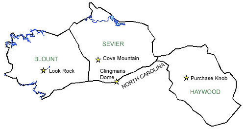
Great Smoky Mountain Area (elevations above 2,500 ft.) Ozone Monitoring Site Information
The Great Smoky Mountain Area (elevations above 2,500 ft.) includes Blount, and Sevier Counties in Tennessee as well as Haywood County in North Carolina.
Clingmans Dome Monitoring Site |
Cove Mountain Monitoring Site |
||
|---|---|---|---|
| AIRS Identification Number: | 471550102 | AIRS Identification Number: | 471550101 |
| County: | Sevier | County: | Sevier |
| Forecast Area: | Great Smoky Mountain Area (elevations above 2,500 ft.) | Forecast Area: | Great Smoky Mountain Area (elevations above 2,500 ft.) |
| Land Usage: | Spruce-fir Forest | Land Usage: | Hardwood Forest |
| Elevation (Above Mean Sea Level) |
6610 feet (2014.73 meters) |
Elevation (Above Mean Sea Level) |
4150 feet (1264.92 meters) |
| Latitude: (Degrees) |
35.562793 (35°33'16.76" N) |
Latitude: (Degrees) |
35.6965305 (35°41'39.18" N) |
| Longitude: (Degrees) |
-83.49807028 (83°29'48.42" W) |
Longitude: (Degrees) |
-83.60985778 (83°36'59.15" W) |
| Years of Operation | 10 years | Years of Operation | 19 years |
| Operated by: | National Park Service | Operated by: | National Park Service |
Look Rock Monitoring Site |
Purchase Knob Monitoring Site |
||
| AIRS Identification Number: | 470090101 | AIRS Identification Number: | 370870036 |
| County: | Blount | County: | Haywood, North Carolina |
| Forecast Area: | Great Smoky Mountain Area (elevations above 2,500 ft.) | Forecast Area: | Great Smoky Mountain Area (elevations above 2,500 ft.) |
| Land Usage: | Pine-Oak Forest | Land Usage: | Forest |
| Elevation (Above Mean Sea Level) |
2700 feet (822.96 meters) |
Elevation (Above Mean Sea Level) |
4902 feet (1494.13 meters) |
| Latitude: (Degrees) |
35.6315022 (35°37'9.01" N) |
Latitude: (Degrees) |
35.5872 (35°35'43.2" N) |
| Longitude: (Degrees) |
-83.94368111 (83°56'22.09" W) |
Longitude: (Degrees) |
-83.0753 (83°4'31.8" W) |
| Years of Operation | 23 years | Years of Operation | 01/01/1995 to present (11 years) |
| Operated by: | National Park Service | Operated by: | NC Division of Air Quality |
Governor Bill Haslam
Follow Us On
Featured Sites
Fleming Training CenterOutreach Initiatives
Tennessee State Parks
TVA Kingston Update
TN Environmental Conference