Division of Air Pollution Control
Ozone Monitoring
Knoxville Area (elev. under 2,500 ft.) Ozone Monitoring Site Information
The Knoxville Area (elevations under 2,500 ft.) includes Anderson, Jefferson, Knox, and Blount Counties in Tennessee.
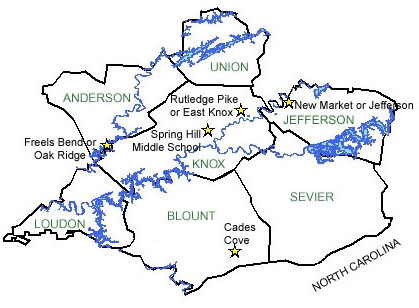
New Market or Jefferson |
Freels Bend or Oak Ridge |
||
|---|---|---|---|
| AIRS Identification Number: | 470890002 | AIRS Identification Number: | 470010101 |
| County: | Jefferson | County: | Anderson |
| Forecast Area: | Knoxville Area (elevations under 2,500 ft.) | Forecast Area: | Knoxville Area (elevations under 2,500 ft.) |
| Land Usage: | Agricultural | Land Usage: | Forest |
| Elevation (Above Mean Sea Level) |
1017 feet (309.98 meters) |
Elevation (Above Mean Sea Level) |
780 feet (237.74 meters) |
| Latitude: (Degrees) |
36.1144444 (36°6'26.67" N) |
Latitude: (Degrees) |
35.965078 (35°57'30.47" N) |
| Longitude: (Degrees) |
-83.601111 (83°36'6.67" W) |
Longitude: (Degrees) |
-84.22323639 (84°13'19.42" W) |
| Years of Operation | 03/01/1999 to present (7 years) |
Years of Operation | 04/01/1992 to present (14 years) |
| Operated by: | TN Department of Environment and Conservation | Operated by: | TN Department of Environment and Conservation |
Look Rock Monitoring Site |
Purchase Knob Monitoring Site |
||
| AIRS Identification Number: | 470090101 | AIRS Identification Number: | 370870036 |
| County: | Blount | County: | Haywood, North Carolina |
| Forecast Area: | Great Smoky Mountain Area (elevations above 2,500 ft.) | Forecast Area: | Great Smoky Mountain Area (elevations above 2,500 ft.) |
| Land Usage: | Pine-Oak Forest | Land Usage: | Forest |
| Elevation (Above Mean Sea Level) |
2700 feet (822.96 meters) |
Elevation (Above Mean Sea Level) |
4902 feet (1494.13 meters) |
| Latitude: (Degrees) |
35.6315022 (35°37'9.01" N) |
Latitude: (Degrees) |
35.5872 (35°35'43.2" N) |
| Longitude: (Degrees) |
-83.94368111 (83°56'22.09" W) |
Longitude: (Degrees) |
-83.0753 (83°4'31.8" W) |
| Years of Operation | 23 years | Years of Operation | 01/01/1995 to present (11 years) |
| Operated by: | National Park Service | Operated by: | NC Division of Air Quality |
Cades Cove Monitoring Site |
Rutledge Pike or East Knox |
||
| AIRS Identification Number: | 470090102 | AIRS Identification Number: | 470930021 |
| County: | Blount | County: | Knox |
| Forecast Area: | Knoxville Area (elevations under 2,500 ft.) | Forecast Area: | Knoxville Area (elevations under 2,500 ft.) |
| Land Usage: | Open Field and Forest | Land Usage: | Agricultural |
| Elevation (Above Mean Sea Level) |
1850 feet (563.88 meters) |
Elevation (Above Mean Sea Level) |
980 feet (298.7 meters) |
| Latitude: (Degrees) |
35.603043 (35°36'18.26" N) |
Latitude: (Degrees) |
36.0850488 (36°5'30.29" N) |
| Longitude: (Degrees) |
-83.783615 (83°47'21.69" W) |
Longitude: (Degrees) |
-83.76465806 (83°45'27.95" W) |
| Years of Operation | 9 years | Years of Operation | 21 years |
| Operated by: | National Park Service | Operated by: | Knox County |
Spring Hill Monitoring Site |
|||
| AIRS Identification Number: | 470931020 | ||
| County: | Knox | ||
| Forecast Area: | Knoxville Area (elevations under 2,500 ft.) | ||
| Land Usage: | Mobile | ||
| Elevation (Above Mean Sea Level) |
1056 feet (321.87 meters) |
||
| Latitude: (Degrees) |
36.0183436 (36°1'50.06" N) |
||
| Longitude: (Degrees) |
-83.87614417 (83°52'36.87" W) |
||
| Years of Operation | 21 years | ||
| Operated by: | Knox County | ||
Governor Bill Haslam
Follow Us On
Featured Sites
Fleming Training CenterOutreach Initiatives
Tennessee State Parks
TVA Kingston Update
TN Environmental Conference