Division of Air Pollution Control
Ozone Monitoring
Memphis Area Ozone Monitoring Site Information
The Memphis Area includes Shelby County in Tennessee as well as DeSoto County in Mississippi, and Crittenden County in Arkansas.
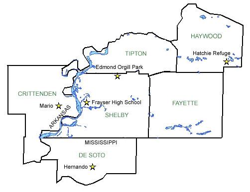
Shelby Monitoring Site |
Hernando Monitoring Site |
||
| AIRS Identification Number: | 471570021 | AIRS Identification Number: | 280330002 |
| County: | Shelby | County: | DeSoto, MS |
| Forecast Area: | Memphis Area | Forecast Area: | Memphis Area |
| Land Usage: | Residential | Land Usage: | Commercial |
| Elevation: (Above Mean Sea Level) |
295 feet (89.92 meters) |
Elevation: (Above Mean Sea Level) |
384 feet (117.04 meters) |
| Latitude: (Degrees) |
35.21753 (35°13'45.18" N) |
Latitude: (Degrees) |
34.822944 (34°49'17.66" N) |
| Longitude: (Degrees) |
-90.01951583 (90°1'57.09" W) |
Longitude: (Degrees) |
-89.982167 (89°58'13" W) |
| Years of Operation: | 30 years | Years of Operation: | |
| Operated by: | Memphis | Operated by: | MDEQ,Mississippi |
Marion Monitoring Site |
Frayser Monitoring Site |
||
| AIRS Identification Number: | 471570021 | AIRS Identification Number: | 471570021 |
| County: | Crittenden | County: | Shelby |
| Forecast Area: | Memphis Area | Forecast Area: | Memphis Area |
| Land Usage: | Residential | Land Usage: | Residential |
| Elevation: (Above Mean Sea Level) |
295 feet (89.92 meters) |
Elevation: (Above Mean Sea Level) |
295 feet (89.92 meters) |
| Latitude: (Degrees) |
35.21753 (35°13'45.18" N) |
Latitude: (Degrees) |
35.21753 (35°13'45.18" N) |
| Longitude: (Degrees) |
-90.01951583 (90°1'57.09" W) |
Longitude: (Degrees) |
-90.01951583 (90°1'57.09" W) |
| Years of Operation: | 30 years | Years of Operation: | 30 years |
| Operated by: | Memphis | Operated by: | Memphis |
Jackson Monitoring Site |
Mario Monitoring Site |
||
| AIRS Identification Number: | 471570021 | AIRS Identification Number: | 050350005 |
| County: | Shelby | County: | Crittenden, Arkansas |
| Forecast Area: | Memphis Area | Forecast Area: | Memphis Area |
| Land Usage: | Residential | Land Usage: | Agricultural |
| Elevation: (Above Mean Sea Level) |
295 feet (89.92 meters) |
Elevation: (Above Mean Sea Level) |
220 feet (67.06 meters) |
| Latitude: (Degrees) |
35.21753 (35°13'45.18" N) |
Latitude: (Degrees) |
35.196667 (35°11'40" N) |
| Longitude: (Degrees) |
-90.01951583 (90°1'57.09" W) |
Longitude: (Degrees) |
-90.191111 (90°11'6.67" W) |
| Years of Operation: | 30 years | Years of Operation: | 22 years |
| Operated by: | Memphis | Operated by: | ADEQ, Arkansas |
Edmond Orgill Monitoring Site |
|||
| AIRS Identification Number: | 471571004 | ||
|---|---|---|---|
| County: | Shelby | ||
| Forecast Area: | Memphis Area | ||
| Land Usage: | Agricultural | ||
| Elevation: (Above Mean Sea Level) |
390 feet (118.87 meters) |
||
| Latitude: (Degrees) |
35.3774783 (35°22'44.87" N) |
||
| Longitude: (Degrees) |
-89.83218583 (89°49'13.11" W) |
||
| Years of Operation: | 22 years | ||
| Operated by: | Memphis | ||
Governor Bill Haslam
Follow Us On
Featured Sites
Fleming Training CenterOutreach Initiatives
Tennessee State Parks
TVA Kingston Update
TN Environmental Conference