


| COUNTY: | Roane | ACREAGE: | 35 |
| 7.5° QUADRANGLE: | Elverton | OWNERSHIP: | Private; State holds a conservation easement |
| PHYSIOGRAPHIC PROVINCE: | Ridge and Valley | YEAR DESIGNATED: | 2006 |
DESCRIPTION: |
 Campbell Bend Barrens
is a 35-acre natural area in the Ridge and Valley Physiographic Province
of East Tennessee. Campbell Bend is approximately one mile to the northeast
of Crowder Cemetery. Both were once a part of a larger natural area complex
(1,200 acres) that was included in the Oak Ridge Reservation (ORR), before
ORR sold the land to Boeing in the mid-1980s. It had been one of seven
ORR Registered State Natural Areas and was recognized as the Campbell
Bend/Crowder Cemetery Registered State Natural Area. The registry agreement
was continued with Boeing Corporation until they sold the 1200 acres to
Rarity Ridge Development in the late 1990s. Rarity Ridge donated conservation
easements to the State, which led to the designation of both natural areas.
Campbell Bend Barrens
is a 35-acre natural area in the Ridge and Valley Physiographic Province
of East Tennessee. Campbell Bend is approximately one mile to the northeast
of Crowder Cemetery. Both were once a part of a larger natural area complex
(1,200 acres) that was included in the Oak Ridge Reservation (ORR), before
ORR sold the land to Boeing in the mid-1980s. It had been one of seven
ORR Registered State Natural Areas and was recognized as the Campbell
Bend/Crowder Cemetery Registered State Natural Area. The registry agreement
was continued with Boeing Corporation until they sold the 1200 acres to
Rarity Ridge Development in the late 1990s. Rarity Ridge donated conservation
easements to the State, which led to the designation of both natural areas.
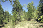
The small barrens community is a rare community type in a region where much of the land base has been developed or converted to agriculture. They occur on extremely thin, cherty silt loam over dolomitic limestone, and are dominated by warm season grasses, legumes, and composites. Eastern red cedar, white pine, post oak, dwarf chinquapin oak (Quercus prinoides), and other hardwoods are scattered throughout the open grassland community and are limited in their distribution by shallow soil. The grassland appears to be maintained by drought conditions associated with thin soil, rock outcropping, and aspect.
The barrens community within the natural area is approximately four to
six acres extending along a ridge and occupying the upper slopes facing
south and west. The dominant grasses at Campbell Bend include little bluestem
and side-oats gramma with big bluestem more common near the bluff. A small
section of the barrens extend to near a bluff overlooking the Clinch River
where the state listed spreading false foxglove (Aureolaria patula)
and naked-stem sunflower (Helianthus occidentalis) occur. The
remainder of natural area that surrounds the grassland barrens is a mature
mesic white pine-hardwood forest with sugar maple, tulip poplar, shagbark
hickory, and white pine as dominant tree species. There is a prominent
sinkhole feature on the north end of the natural area where the hardwood
forest extends.
SITE MANAGEMENT:
Division of Natural Areas, 401 Church Street, 7th Floor L&C Annex, Nashville, TN 37243, (615) 532-0431; Division of Natural Areas – East TN office, 3711 Middlebrook Pike, Knoxville, TN 37921, (865) 594-5601.
PUBLIC ACCESS:
The property is privately owned and not open to the public at this time.
DIRECTIONS:
Directions are not provided until public access is completed. Click on the map link to view natural area’s location.
