


| COUNTY: | Rutherford | ACREAGE: | 846 |
| 7.5' QUADRANGLE: | Dilton | OWNERSHIP: | The Nature Conservancy, State of TN |
| PHYSIOGRAPHIC PROVINCE: |
Central Basin | YEAR DESIGNATED: |
1999 |
DESCRIPTION: |
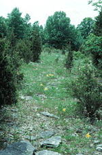 Flat
Rock Cedar Glade and Barrens is located about eight miles east of Murfreesboro,
Tennessee in the geographic center of the Central Basin in Rutherford
County. Flat Rock supports a mosaic of forest types, oak barrens, open
grassland barrens, and cedar glades, including federal and state listed
plant species and glade endemic species. These glades are characterized
by exposed limestone that is typically interspersed with cedar-oak-hickory
forest that occurs in deeper soils. This limestone, with its many sinkholes,
is a karst topography commonly associated with glades.
Flat
Rock Cedar Glade and Barrens is located about eight miles east of Murfreesboro,
Tennessee in the geographic center of the Central Basin in Rutherford
County. Flat Rock supports a mosaic of forest types, oak barrens, open
grassland barrens, and cedar glades, including federal and state listed
plant species and glade endemic species. These glades are characterized
by exposed limestone that is typically interspersed with cedar-oak-hickory
forest that occurs in deeper soils. This limestone, with its many sinkholes,
is a karst topography commonly associated with glades.
Flat Rock Cedar Glades and Barrens support a diversity of annual grasses, including sporobolus and aristida. Rare plants associated with these cedar glades include Tennessee milk-vetch (Astragalus tennesseensis), Missouri primrose (Oenothera missouriensis), and limestone fame-flower (Talinum calcaricum). Small creek tributaries and flat gravelly wash areas provide specialized habitat for rare plants, including the federally endangered leafy prairie-clover (Dalea foliosa), the state listed yellow sunnybells (Schoenolirion croceum), low nut rush (Scleria verticillata), and Boykin's milkwort (Polygala boykinii). Little bluestem (Schizachyrium scoparium) and cedar trees occur in pockets of deep soil scattered across the glades. Open grassland barrens found in deeper soils are dominated by little bluestem and side-oats grama (Bouteloua curtipendula). Flat Rock barrens support numerous state listed species, including wavy-leaf purple coneflower (Echinacea simulata), southern prairie-dock (Silphium pinnatifidum) and slender blazing-star (Liatris cylindracea). These same species occur in the open canopy post oak forest areas referred to as an "oak barrens." Flat Rock is also significant as the type location for the federal listed Pyne's ground-plum (Astragalus bibullatus).
Flat Rock Cedar Glades and Barrens is one of Tennessee's most ecologically significant natural areas and is an important research natural area. It is located only a few miles from Middle Tennessee State University. Flat Rock is jointly owned and managed by The Nature Conservancy of Tennessee and the State of Tennessee.
SITE MANAGEMENT:
The Nature Conservancy, Tennessee Chapter; 2021 21st Ave., South, Suite C 400, Nashville, TN 37212, phone (615) 383-9909; Division of Natural Areas, 401 Church Street, 7th Floor L&C Annex, Nashville, TN 37243, phone (615) 532-0431.
PUBLIC ACCESS:
Public access allowed; parking and hiking trails are provided.
DIRECTIONS:
From I-24 exit 81 B and go about one quarter mile on Church St. and turn right on S. Rutherford Blvd. and then proceed approximately five miles and turn right at Greenland and proceed three miles east on Halls Hill Pike, then turn right on Factory Rd. Follow Factory Rd for one mile to the parking lot on the right.
