


| COUNTY: | Morgan | ACREAGE: | 12,570 |
| 7.5' QUADRANGLE: | Fork Mountain, Camp Austin, Petros, and Gobey |
OWNERSHIP: | State of Tennessee |
| PHYSIOGRAPHIC PROVINCE: |
Cumberland Plateau | YEAR DESIGNATED: | 1974 |
DESCRIPTION: |
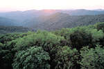 Frozen
Head is 12,570-acre natural area in Morgan County. It is one of the crown
jewels of Tennessee’s Cumberland Mountain range and is an excellent
example of what pre-settlement conditions might have been like here hundreds
of years ago. The Cumberland Mountains occupy the northeast section of
the Cumberland Plateau and has an elevation range that rises more than
1,000 feet above the Plateau. The highest peak in the natural area occurs
on Frozen Head Mountain at 3,324 feet elevation. There are thirteen other
peaks in the natural area rising above 3,000 feet elevation. The name
“Frozen Head” derives from the peaks that are often capped
in a shroud of snow or ice in winter. The majority of this land was acquired
by the State in early 1900’s to become a state forest for hardwood
timber production, but very little timber was ever harvested.
Frozen
Head is 12,570-acre natural area in Morgan County. It is one of the crown
jewels of Tennessee’s Cumberland Mountain range and is an excellent
example of what pre-settlement conditions might have been like here hundreds
of years ago. The Cumberland Mountains occupy the northeast section of
the Cumberland Plateau and has an elevation range that rises more than
1,000 feet above the Plateau. The highest peak in the natural area occurs
on Frozen Head Mountain at 3,324 feet elevation. There are thirteen other
peaks in the natural area rising above 3,000 feet elevation. The name
“Frozen Head” derives from the peaks that are often capped
in a shroud of snow or ice in winter. The majority of this land was acquired
by the State in early 1900’s to become a state forest for hardwood
timber production, but very little timber was ever harvested.
The lowest elevation is at the Flat Fork access at 1,340 feet. The deep hollows and valleys here provide vast rich forest habitat that support numerous forest community types. Those most prevalent are the many different communities (or segregates) of mixed mesophytic forest that include species of hemlock, white pine, tulip poplar, sugar and red maples, many species of oaks and hickories, yellowwood, yellow birch, ash species, walnut, blackgum, beech, sourwood, basswood, magnolias, and black cherry. A mesic oak forest occurs as basswood and buckeye begin to dropout at the mid and upper slope level. White oak becomes the dominant tree here along with tulip poplar and other species commonly found in the mixed mesophytic forest. At higher elevations and on dry slopes and ridges, scarlet and chestnut oaks become more common along with shortleaf pine.
Frozen Head is a favorite destination for spring wildflower walks and birdwatchers. The spring wildflower display rivals the Smokies. This vast unfragmented forest provides nesting habitat for many neotropical migrants like the cerulean warbler. There are almost 60 miles of trails that meander through the natural area, many of which were constructed by the Civilian Conservation Corps in the 1930’s. Animal life is also abundant at Frozen Head as many species of birds, reptiles and amphibians are found in diverse habitats. The area contains significant mature forest and rare plants, and is one of the least disturbed areas remaining within the Cumberland Mountains of Tennessee.
SITE MANAGEMENT:
Frozen Head State Natural Area, 964 Flat Fork Road, Wartburg, TN 37887, and (423) 346-3318. Division of Natural Areas, 401 Church Street, 7th Floor L&C Annex, Nashville, TN 37243-0447, (615) 532-0431.
PUBLIC ACCESS:
Public access is allowed: parking and hiking trails are provided and camping is allowed by fee and permit in developed camping areas; no fee is assessed for backcountry camping sites, but a permit is required.
DIRECTIONS:
From Oak Ridge take State Route 62 west toward the towns of Oliver Springs and Wartburg. Keep going straight past State Route 116 which turns north toward Petros. About 6 miles past the road to Petros, you will see signs for Frozen Head. Turn right on Flat Fork Road and continue straight down the valley to the park and natural area.
