


| COUNTY: | Scott | ACREAGE: | 109 |
| 7.5' QUADRANGLE: | Honey Creek | OWNERSHIP: | National Park Service |
| PHYSIOGRAPHIC PROVINCE: |
Cumberland Plateau | YEAR DESIGNATED: |
1973 |
DESCRIPTION: |
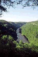 Honey
Creek is a 109-acre natural area in Pickett County. It is one of two designated
state natural areas located in the Big South Fork National River and Recreation
Area (BISO) owned and managed by the National Park Service. It was previously
a Bowater Pocket Wilderness Area before the BISO was established. One
of its most outstanding features is the incredibly scenic overlook 250
feet above the South Fork of Cumberland River. It is noted in various
hiking guidebooks that Honey Creek provides spectacular scenery. There
is a rugged five-mile loop trail that traverses much of the gorge. It
crosses many small streams, several cascading waterfalls, sheer cliffs,
and passes under large rock houses once used by Native Americans. Hikers
are advised to allow five to eight hours for this hike and to be in good
physical condition. An alternate, shorter, non-looping trail leaves from
the parking area and goes straight to the overlook for hikers not wishing
to take the complete hike.
Honey
Creek is a 109-acre natural area in Pickett County. It is one of two designated
state natural areas located in the Big South Fork National River and Recreation
Area (BISO) owned and managed by the National Park Service. It was previously
a Bowater Pocket Wilderness Area before the BISO was established. One
of its most outstanding features is the incredibly scenic overlook 250
feet above the South Fork of Cumberland River. It is noted in various
hiking guidebooks that Honey Creek provides spectacular scenery. There
is a rugged five-mile loop trail that traverses much of the gorge. It
crosses many small streams, several cascading waterfalls, sheer cliffs,
and passes under large rock houses once used by Native Americans. Hikers
are advised to allow five to eight hours for this hike and to be in good
physical condition. An alternate, shorter, non-looping trail leaves from
the parking area and goes straight to the overlook for hikers not wishing
to take the complete hike.
The gorge forest at Honey Creek is a diverse mixed mesophytic forest comprised of tulip poplar, eastern hemlock, basswood, magnolia, yellow buckeye, beech, maples, oaks and hickories and other tree species. The ever-present rhododendron thicket is common here. The upland is a typical dry plateau oak – pine forest. There are small sandstone openings that form glades on exposed bluffs. The federally listed Virginia spiraea (Spiraea virginiana) occurs in the rocky bars along the Big South Fork of the Cumberland River just below the Honey Creek overlook. The Virginia spiraea is also found at other locations in the BISO, as is another federally listed species, the Cumberland rosemary (Conradina verticillata).
SITE MANAGEMENT:
Big South Fork National River and Recreation Area Park Headquarters, 4564 Leatherwood Road, Oneida, Tennessee 37841, phone (865) 569-9778; Division of Natural Areas, 401 Church Street, 7th Floor L&C Annex, Nashville, TN 37243, phone (615) 532-0431; Division of Natural Areas- East TN office, 3711 Middlebrook Pike, Knoxville, TN 37921, phone (865) 594-5601.
PUBLIC ACCESS:
Public access is allowed; parking and hiking trails are provided. A good trail map is located on the web at: https://www.nps.gov/biso/index.htm. From that page, select the link on the left for “hiking trails” (under “Recreation Opportunities”) and then scroll down the resulting page on the right until you find the link for Honey Creek Loop.
DIRECTIONS:
On State Highway 52 going east out of Allardt, TN, take Mt. Helen Road on the left (this will be a right if you’re traveling west on Hwy. 52 out of Rugby, TN). Go down Mt. Helen Road. It will fork. Take the left fork bearing toward Zenith. When you see signs for Zenith, continue straight, heading northeast. The turn to the Honey Creek Overlook and trailhead parking will be on your left.
