


| COUNTY: | Rhea | ACREAGE: | 2,259 |
| 7.5' QUADRANGLE: | Morgan Springs | OWNERSHIP: | State of Tennessee |
| PHYSIOGRAPHIC PROVINCE: |
Cumberland Plateau | YEAR DESIGNATED: |
1973 |
DESCRIPTION: |
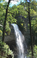 Laurel-Snow
is a 2,259-acre natural area located in Rhea County. The natural area
occurs on the Walden Ridge of the Cumberland Plateau and contains a section
of gorge that is deeply dissected by Morgan, Henderson, Laurel, and Richland
Creeks. The site is named after two scenic waterfalls, Laurel Falls (80
feet) and Snow Falls (35 feet), and features two prominent overlooks,
Buzzard Point and Bryan Overlook (also known as Raven Point). The natural
area also has scenic creeks, steep gorges, geologic features, a small
stand of virgin timber, and a wide variety of plants. Buzzard Point and
to Snow Falls can be hiked to by following the trail as it forks to the
left going west. The trail to the right leads to Raven Point, which overlooks
Laurel Snow. The trail eventually climbs to the top of the falls. The
distance for both trails is about 10.5 round trip.
Laurel-Snow
is a 2,259-acre natural area located in Rhea County. The natural area
occurs on the Walden Ridge of the Cumberland Plateau and contains a section
of gorge that is deeply dissected by Morgan, Henderson, Laurel, and Richland
Creeks. The site is named after two scenic waterfalls, Laurel Falls (80
feet) and Snow Falls (35 feet), and features two prominent overlooks,
Buzzard Point and Bryan Overlook (also known as Raven Point). The natural
area also has scenic creeks, steep gorges, geologic features, a small
stand of virgin timber, and a wide variety of plants. Buzzard Point and
to Snow Falls can be hiked to by following the trail as it forks to the
left going west. The trail to the right leads to Raven Point, which overlooks
Laurel Snow. The trail eventually climbs to the top of the falls. The
distance for both trails is about 10.5 round trip.
The land use history of this area remains evident in places. Logging and deep mining took place in some portions of the area in the late 1800's and early 1900's. Some remnants of the mining activities can still be seen along the trail near the parking area. Part of Henderson Creek was dammed to serve as the Dayton Reservoir and was once the water supply for the town of Dayton. The low dam across the stream can still be seen, although water is no longer collected here for the town. The Laurel-Snow trail was the first National Recreation Trail designated in Tennessee. See https://www.americantrails.org/national-recreation-trails/featured? for more information.
Laurel-Snow State Natural Area is managed by the Cumberland Trail State Scenic Trail, and the area includes trailhead parking and an open section of the Cumberland Trail. Backcountry camping is available on the area at this time. See Cumberland Trail for more information. The Cumberland Trail, the state's only linear state park, when completed will be 300 miles in length cutting through 11 Tennessee counties from the Cumberland Gap National Historic Park on the Tennessee-Virginia-Kentucky border to the Signal Point near Chattanooga.
SITE MANAGEMENT:
South Trail Office, 1327 Montlake Road, Soddy Daisy, TN 37379 or P.O. Box 571 Soddy Daisy, TN 37384, phone (423) 332-7394; Division of Natural Areas, 401 Church Street, 7th Floor L&C Annex, Nashville, TN 37243, phone (615) 532-0431.
PUBLIC ACCESS:
Public access is allowed; parking and hiking trails are provided. The natural area has 10.5 miles of hiking trails. Backcountry camping is by permit only, call (423) 332–7394 for backcountry camping information and permit.
DIRECTIONS:
Laurel-Snow is located north of Dayton and is accessible via Highway 27/29. From the north turn right, and from the south turn left, onto Walnut Grove Road north of Dayton (new Eckerd Drug on corner). Proceed 3/4 of a mile to Back Valley Road (pass La-Z-Boy factory) and turn left. On Back Valley Road, proceed 0.7 miles to an unmarked gravel road/Richland Creek Road (small white church on the left) and turn right. Proceed about 1 mile to the parking area at the end of Richland Creek Road.
