


| COUNTY: | Franklin | ACREAGE: | 3 Acres |
| 7.5' QUADRANGLE: | Sewanee | OWNERSHIP: | State of Tennessee |
| PHYSIOGRAPHIC PROVINCE: |
Cumberland Plateau | YEAR DESIGNATED: | 1973 |
DESCRIPTION: |
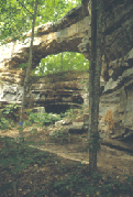 Natural
Bridge is a three- acre natural area located in Franklin County. Natural
Bridge is a 25 feet high natural sandstone arch with a span of 50 feet
that provides a scenic overlook of Lost Cove. There is a wet weather spring
associated with a rock house located behind the natural bridge. The spring
probably contributed to the formation of the arch. Lost Cove is a large
karst formation on the dissected section of the Cumberland Plateau. It
is essentially a giant sinkhole. Lost Creek flows into the valley and
disappears into Lost Cove Cave at the Big Sinks and re-emerges as Crow
Creek from Buggytop Cave within Mr. & Mrs. Harry Lee Carter State
Natural Area. The site also has been referred to as Sewanee Natural Bridge
since the University of the South in Sewanee once owned it. The natural
area is a part of the South Cumberland Recreation Area.
Natural
Bridge is a three- acre natural area located in Franklin County. Natural
Bridge is a 25 feet high natural sandstone arch with a span of 50 feet
that provides a scenic overlook of Lost Cove. There is a wet weather spring
associated with a rock house located behind the natural bridge. The spring
probably contributed to the formation of the arch. Lost Cove is a large
karst formation on the dissected section of the Cumberland Plateau. It
is essentially a giant sinkhole. Lost Creek flows into the valley and
disappears into Lost Cove Cave at the Big Sinks and re-emerges as Crow
Creek from Buggytop Cave within Mr. & Mrs. Harry Lee Carter State
Natural Area. The site also has been referred to as Sewanee Natural Bridge
since the University of the South in Sewanee once owned it. The natural
area is a part of the South Cumberland Recreation Area.
SITE MANAGEMENT:
South Cumberland Recreation Area (www.tnstateparks.com/SouthCumberland/), 11745 US 41, Monteagle, TN 37356, phone (931) 924-2980. Division of Natural Areas, 401 Church Street, 7th Floor L&C Annex, Nashville, TN 37243-0447, phone (615) 532-0431.
PUBLIC ACCESS:
Public access allowed; parking and a short hiking trail is provided. The natural area is operated by Tennessee State Parks.
DIRECTIONS:
Natural Bridge is located south of Sewanee. The natural area is accessed via Highway Alt. 41. In Sewanee turn south onto Highway 56 and proceed 2.5 miles to Natural Bridge Road. Turn left onto Natural Bridge Road and proceed one half mile to the parking area.
