


| COUNTY: | Rhea | ACREAGE: | 783 Acres |
| 7.5' QUADRANGLE: | Pennine | OWNERSHIP: | State of Tennessee |
| PHYSIOGRAPHIC PROVINCE: |
Cumberland Plateau | YEAR DESIGNATED: | 1973 |
DESCRIPTION: |
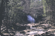 Stinging
Fork Falls is a 783-acre natural area located in Rhea County. It is named
for the 30-foot waterfall located within the Stinging Fork gorge. The
creek flows over the fan shaped falls, then quickly slips through chutes,
and tumbles over cascades below the falls. The gorge contains a second
growth mixed mesophytic forest community. Steep cliffs may be found along
the smaller bluffs that descend into the gorge. An oak-pine forest can
be found along the gorge bluff. Indian Head Point provides a view of the
gorge and creek 160 feet below. Much of the upland area between the parking
area and gorge had been planted by Bowater in loblolly pine (Pinus taeda),
and has since been removed due to heavy southern pine beetle impact. This
area is undergoing hardwood succession.
Stinging
Fork Falls is a 783-acre natural area located in Rhea County. It is named
for the 30-foot waterfall located within the Stinging Fork gorge. The
creek flows over the fan shaped falls, then quickly slips through chutes,
and tumbles over cascades below the falls. The gorge contains a second
growth mixed mesophytic forest community. Steep cliffs may be found along
the smaller bluffs that descend into the gorge. An oak-pine forest can
be found along the gorge bluff. Indian Head Point provides a view of the
gorge and creek 160 feet below. Much of the upland area between the parking
area and gorge had been planted by Bowater in loblolly pine (Pinus taeda),
and has since been removed due to heavy southern pine beetle impact. This
area is undergoing hardwood succession.
The Stinging Fork Falls trail terminates at the bottom of the falls about 1 mile from the parking area. A future segment of the Cumberland Trail is planned to connect to Stinging Fork Falls. See www.tnstateparks.com/CumberlandTrail/ for more information.
SITE MANAGEMENT:
Division of Natural Areas, 401 Church Street, 7th Floor L&C Tower Annex, Nashville, TN 37243, phone (615) 532-0431. Cumberland Trail State Park, South Trail Office, 1327 Montlake Road, Soddy Daisy, TN 37379 or P.O. Box 571, Soddy Daisy, TN 37384, phone (423) 332-7394.
PUBLIC ACCESS:
Public access is allowed; trailhead parking and a hiking trail are provided. Camping and open fires are prohibited.
DIRECTIONS:
Stinging Fork Falls is located west of Spring City. Access to the natural area is via Highway 68. In Spring City turn onto Shut-In Gap Road and proceed five miles to the parking area on the right.
