


| COUNTY: | Carter | ACREAGE: | 50 |
| 7.5' QUADRANGLE: | Johnson City | OWNERSHIP: | State of Tennessee |
| PHYSIOGRAPHIC PROVINCE: |
Ridge and Valley | YEAR DESIGNATED: | 1998 |
DESCRIPTION: |
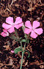 Watauga
River Bluffs is a 50-acre natural area located in Carter County along
the Watauga River. Its most conspicuous feature is the steep slope that
drops more than 200 feet to the river's edge. The slope and the narrow
bluffs make up most of the 50 acres. It is ecology noteworthy because
Watauga River Bluff supports the largest known population of the state
listed Carolina pink (Silene caroliniana). This population is mostly
concentrated in an open dry chestnut oak forest occurring on the west
to south facing upper slopes. This community has white ash as an associate
canopy species and a sub-canopy comprised of bitternut hickory, eastern
red cedar, and serviceberry. This community has a spare herbaceous layer.
This is an early succession forest that is estimated to be approximately
60 or more years old.
Watauga
River Bluffs is a 50-acre natural area located in Carter County along
the Watauga River. Its most conspicuous feature is the steep slope that
drops more than 200 feet to the river's edge. The slope and the narrow
bluffs make up most of the 50 acres. It is ecology noteworthy because
Watauga River Bluff supports the largest known population of the state
listed Carolina pink (Silene caroliniana). This population is mostly
concentrated in an open dry chestnut oak forest occurring on the west
to south facing upper slopes. This community has white ash as an associate
canopy species and a sub-canopy comprised of bitternut hickory, eastern
red cedar, and serviceberry. This community has a spare herbaceous layer.
This is an early succession forest that is estimated to be approximately
60 or more years old.
The steep slopes are extremely fragile as shale fragments continuously slough off and results in talus that accumulates near the bottom. The chestnut oak extends down slope where more mesic conditions and deeper soils support white oak, eastern hemlock, tulip poplar, and yellow buckeye trees. There is an area adjacent to the bluff where hemlock is prevalent. This area, and much of the lower slopes are rich with spring wildflowers and ferns that include hepatica, trilliums, spring beauties, Jacobs ladder, and trout lily.
The river bluff natural area has been undeveloped and unoccupied since the 1950's. Today it remains a rugged landscape harboring a diverse plant community. Its varied mix of habitats, soil depth, and other geological features may yield more rare species upon further investigation. The surrounding area has been used for agriculture in the past and is now a residential area interspersed with old pastures. The area south of the bluffs has been scarred by coal and shale extraction and has been planted in clover and fescue. The spread of invasive exotic pest plants pose a serious problem because of past disturbance and a fragmented landscape.
SITE MANAGEMENT:
Division of Natural Areas, 401 Church Street, 7th Floor L&C Annex, Nashville, TN 37243, phone (615) 532-0431; Division of Natural Areas - East TN office, 3711 Middlebrook Pike, Knoxville, TN 37921, phone (865) 594-5601.
PUBLIC ACCESS:
No access has been developed, but the public can visit the area by-way-of the “Park ‘n Fish,” which is an area where a neighboring landowner allows one vehicle at a time to park. From State Route 400 (Watauga Road), on the west side of the village of Watauga, turn onto the Steam Plant Road. Cross the railroad tracks and continue past the little church. Make a hard right toward the end of this stretch past the church and go to the end of the road, where you will see the “Park ‘n Fish” sign. From there, a social trail to the river will be evident.
