


| COUNTY: | Knox | ACREAGE: | 500 |
| 7.5' QUADRANGLE: | John Sevier | OWNERSHIP: | State of Tennessee |
| PHYSIOGRAPHIC PROVINCE: |
Ridge and Valley | YEAR DESIGNATED: | 1987 |
DESCRIPTION: |
 House
Mountain is a 500-acre natural area located in Knox County approximately
eight miles from Knoxville. It is cooperatively managed under a lease
agreement with the State by the Knox County Department of Parks and Recreation.
The 2,100-foot crest of House Mountain provides significant vistas where
visitors may scan the parallel ranges of the Unakas and Cumberlands some
30 miles away, or look northeast at the adjacent Clinch Mountain, and
across the valley where the Trail of the Lonesome Pine may some day lead
north into Virginia.
House
Mountain is a 500-acre natural area located in Knox County approximately
eight miles from Knoxville. It is cooperatively managed under a lease
agreement with the State by the Knox County Department of Parks and Recreation.
The 2,100-foot crest of House Mountain provides significant vistas where
visitors may scan the parallel ranges of the Unakas and Cumberlands some
30 miles away, or look northeast at the adjacent Clinch Mountain, and
across the valley where the Trail of the Lonesome Pine may some day lead
north into Virginia.
 Before
erosion by Big Flat Creek, the gently dipping bedrock layers underlying
House Mountain once extended to Clinch Mountain, whose base lies approximately
two and half miles to the northeast. The bedrock structure represents
a large synclinal fold that formed during the Appalachian mountain building
event called the Alleghenian Orogeny. Folding and faulting of the bedrock
occurred approximately 250 million years ago when tectonic plate motions
caused the collision between North America and Africa. Through geologic
time, dissolution and erosion has separated House Mountain from its larger
parent. It is one of the best observable examples of geologic change that
shaped the Ridge and Valley of East Tennessee.
Before
erosion by Big Flat Creek, the gently dipping bedrock layers underlying
House Mountain once extended to Clinch Mountain, whose base lies approximately
two and half miles to the northeast. The bedrock structure represents
a large synclinal fold that formed during the Appalachian mountain building
event called the Alleghenian Orogeny. Folding and faulting of the bedrock
occurred approximately 250 million years ago when tectonic plate motions
caused the collision between North America and Africa. Through geologic
time, dissolution and erosion has separated House Mountain from its larger
parent. It is one of the best observable examples of geologic change that
shaped the Ridge and Valley of East Tennessee.
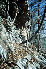
The steep slopes of House Mountain are heavily wooded and possess a unique combination of scenic views, rock outcrops, and a variety of bird and plant life. This is a rare combination of scenic and ecological values near a metropolitan area. Great sandstone boulders, encrusted with lichens, crown the western rim where rock outcropping support chestnut oak and Virginia, pitch, and table mountain pine. Mountain laurel, huckleberry, partridgeberry, trailing arbutus, and other flowering plants adapted to dry sandstone outcropping are found along the crest. A chestnut oak forest extends down slope where at lower elevations soil conditions associated with limestone, moister deeper soils, and north-facing slopes support a forest of sugar maple, tulip poplar, ash, buckeye, and other mesophytic species. This moister habitat favors the greatest density and diversity of spring wildflowers.
House Mountain is a favorite place for birdwatchers. Migrating hawks and warblers can be observed from the mountain. Ruffed grouse, pileated woodpeckers, scarlet tanagers, wild turkeys, and more than one hundred additional species of birds have been observed on the mountain. House Mountain is drained by several unnamed tributaries of Roseberry Creek and by Hogskin and Brice Branches, which divide it from the 1,500 feet high McAnnally Ridge, which lies to the east and south. Unfortunately, past disturbances and House Mountain’s close proximately to Knoxville have resulted in serious management concerns caused by invasive exotic pest plants.
SITE MANAGEMENT:
Knox County Department of Parks and Recreation, 2447 Sutherland Avenue, Knoxville, TN 37919, phone (865) 215-6600; Division of Natural Areas, 401 Church Street, 7th Floor L&C Annex, Nashville, TN 37243, phone (615) 532-0431; Division of Natural Areas – East TN office, 3711 Middlebrook Pike, Knoxville, TN 37921, phone (865) 594-5601.
PUBLIC ACCESS:
Public access is allowed; parking and hiking trails are provided.
DIRECTIONS:
From Knoxville, Tennessee, take I-40 East. Exit on U.S. Highway 11W (Rutledge Pike) and go north and east on Rutledge Pike. After about 10 miles, look for the “House Mountain State Park” sign on the right side of the highway and then turn left on Idumea Road. Turn left on Hogskin Road. The parking area is less than a mile on the right.
