


| COUNTY: | Grundy and Sequatchie | ACREAGE: | 15,590 Acres |
| 7.5' QUADRANGLE: | Altamont and Collins | OWNERSHIP: | State of Tennessee |
| PHYSIOGRAPHIC PROVINCE: |
Cumberland Plateau | YEAR DESIGNATED: | 1974 |
DESCRIPTION: |
 Savage
Gulf is 15,590-acre natural area located in Grundy and Sequatchie Counties.
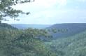
Carved like a giant crowfoot into the western edge of the Cumberland Plateau,
it is one of Tennessee's most scenic wilderness areas. Its sheer sandstone
cliffs and rugged canyons provide extraordinary views. A significant feature
is Stone Door, a 10 ft. wide by 100 ft. deep crack, forming from the top
of the escarpment into the gorge below. It looks like a giant door left
ajar and was once used by Indians as a passageway. Breathtaking waterfalls
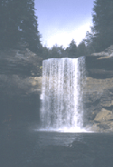
form at the head of many gorges, where streams drop off over hard sandstone
cap rock. Greeter Falls drops over a 15-foot upper ledge and then plummets
over a 50-foot lower ledge into a cold, clear plunge pool. Savage Creek
enters its gorge over cascades and drops 30-foot at Savage Falls. Collins
River and Ranger Creek have waterfalls that drop over limestone ledges
and flow into sinks where they disappear. Big Creek, Collins River and
Savage Creeks each tumble down over 5 miles, dropping over 800 feet through
narrow gorges, forming the "Gulfs." Observed from a 750 overlook,
Big Creek mysteriously disappears below. Many other big streams go underground
cutting through shale and limestone to form dry creek beds. Sudden heavy
rainfall however can result in flashfloods, and streams can become are
very dangerous.
Savage
Gulf is 15,590-acre natural area located in Grundy and Sequatchie Counties.
Carved like a giant crowfoot into the western edge of the Cumberland Plateau,
it is one of Tennessee's most scenic wilderness areas. Its sheer sandstone
cliffs and rugged canyons provide extraordinary views. A significant feature
is Stone Door, a 10 ft. wide by 100 ft. deep crack, forming from the top
of the escarpment into the gorge below. It looks like a giant door left
ajar and was once used by Indians as a passageway. Breathtaking waterfalls
form at the head of many gorges, where streams drop off over hard sandstone
cap rock. Greeter Falls drops over a 15-foot upper ledge and then plummets
over a 50-foot lower ledge into a cold, clear plunge pool. Savage Creek
enters its gorge over cascades and drops 30-foot at Savage Falls. Collins
River and Ranger Creek have waterfalls that drop over limestone ledges
and flow into sinks where they disappear. Big Creek, Collins River and
Savage Creeks each tumble down over 5 miles, dropping over 800 feet through
narrow gorges, forming the "Gulfs." Observed from a 750 overlook,
Big Creek mysteriously disappears below. Many other big streams go underground
cutting through shale and limestone to form dry creek beds. Sudden heavy
rainfall however can result in flashfloods, and streams can become are
very dangerous.
 While
much of the gorge is second growth forest, there is one large section
of old growth mixed mesophytic forest in the gorge. The gorge forests
abound with oaks, hickories, maples, yellow poplars, hemlocks, pines and
many other tree species. Beneath the forest canopy is a vast array of
shrubs, vines, wildflowers, mosses and ferns. Collins Gulf is noted for
its spectacular display of spring wildflowers. In the uplands, an old
growth short leaf pine forest is found where red cockaded woodpeckers
once nested. The natural area is a part of the South Cumberland State
Park. Savage Gulf is also on the Registry of National Natural Landmarks.
While
much of the gorge is second growth forest, there is one large section
of old growth mixed mesophytic forest in the gorge. The gorge forests
abound with oaks, hickories, maples, yellow poplars, hemlocks, pines and
many other tree species. Beneath the forest canopy is a vast array of
shrubs, vines, wildflowers, mosses and ferns. Collins Gulf is noted for
its spectacular display of spring wildflowers. In the uplands, an old
growth short leaf pine forest is found where red cockaded woodpeckers
once nested. The natural area is a part of the South Cumberland State
Park. Savage Gulf is also on the Registry of National Natural Landmarks.
SITE MANAGEMENT:
South Cumberland State Park (www.tnstateparks.com/SouthCumberland/), 11745 US 41, Monteagle, TN 37356, phone (931) 924-2980; Savage Gulf Ranger Station, Route 1, P.O. Box 253, Palmer, TN 37365, phone (931) 779-3532; Stone Door Ranger Station, P.O. Box 561, Beersheba Springs, TN 37305, phone (931) 692-3887. Division of Natural Areas, 401 Church Street, 7th Floor L&C Annex, Nashville, TN 37243-0447, phone (615) 532-0431.
PUBLIC ACCESS:
The natural area is operated by Tennessee State Parks. Four parking areas, over 50 miles of hiking trails, backcountry camping, and picnic areas are available. Trail maps are available at the SCRC visitor center.
DIRECTIONS:
The Stone Door Entrance is accessed via Highway 56 in Beersheba Springs. Turn on Stone Door Road and proceed straight to the area's entrance. This natural area is a part of the South Cumberland Recreation Area. The Savage Gulf entrance and ranger station is located halfway along Highway 399 between Cagle and Gruetli-Laager.
